

Wild winds and thundery rain are expected to cause chaos across the UK today as a storm named Storm Noa unleashes brutal winds and rain across the country.
The Met Office has issued a yellow weather warning for much of the country, including the Southwest, London, Wales, and Northern Ireland, with heavy showers and thunderstorms with winds of up to 70mph forecast.
Some delays to road, rail, air and ferry transport are likely, with some bus and train services affected, and journeys taking longer. Delays for high-sided vehicles on exposed routes and bridges are also expected, with some short-term loss of power and other services possible.

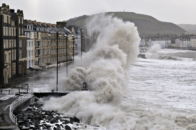
Coastal routes, seafronts, and coastal communities are also likely to be affected by spray and/or large waves.
The storm has already caused substantial traffic disruption across Wales, with parts of the M5 and the old Severn Bridge affected since 9.45am this morning.
The M4 Kenfig Bridge Westbound has been closed because of winds from J37 A4229 (Pyle / Porthcawl) to J38 A48 (Margam), while the M4 Briton Ferry Bridge in Port Talbot Eastbound is closed, causing traffic delays from J42 A483 (Swansea East / Briton Ferry) to J41 (Baglan / Pentyla).

The M48 Severn Bridge is also closed in both directions due to strong winds between J2 A466 Wye Valley Link Road (Chepstow) and J1 A403 (Aust). Cameras show both sides of the bridge are now closed.
The Met Office has warned Britain to brace for 75mph gale force winds with flying debris and damage to buildings expected. The dramatic winds, which are “associated” with Storm Noa, will increase during Wednesday morning and peak during the middle of the day.
A yellow weather warning has been issued for major regions in the South West of England and Wales, including Swansea, Somerset, Cornwall, and Devon. West or northwest winds in association with Storm Noa will continue to increase during Wednesday morning, peaking through the middle of the day, when 50 to 60 mph gusts are expected.
Gusts of 70 to 75 mph are possible along parts of the north coast of Devon and Cornwall, as well as exposed headlands elsewhere. Outbreaks of heavy rain or showers will accompany the strong winds.
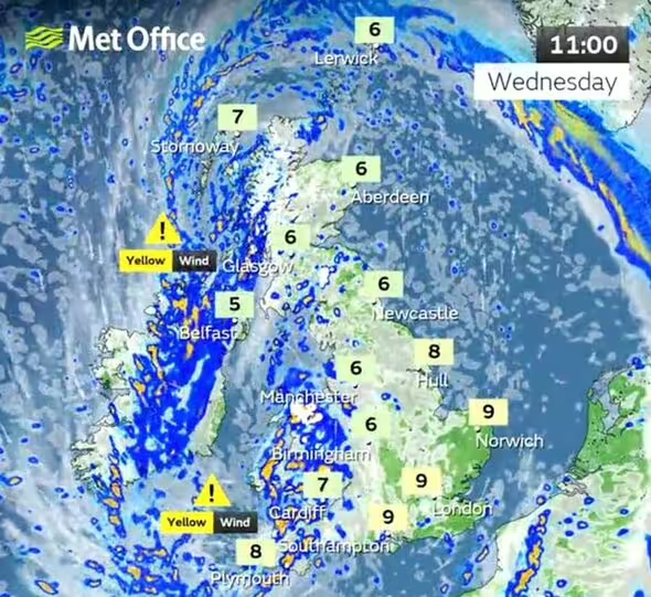
According to the latest forecast by the Met Office, the UK can expect strong winds, low temperatures, and heavy rain or showers today.
Thick cloud and heavy rain will continue to push in from the west, bringing 50 to 60mph winds along western coasts.
Snow is likely to fall over parts of upland Scotland overnight. Some disruption due to strong winds is likely, especially in southern and western areas, as well as the potential for heavy rainfall and even some snow, though the latter is probably confined to high ground in the north. I
t will be another cool day with temperatures of 7C to 10C in the west, with 11C to 13C possible in the southeast. However, it will feel colder in the strong winds.
In summary, Storm Noa is causing widespread disruption across the UK with heavy rain, strong winds, and even snow in some areas.
Some roads and bridges have been closed due to the storm, and transportation is expected to be affected. Coastal areas are at risk of spray and/or large waves, and there may be short-term loss of power and other services. The public is advised to take precautions and stay aware of the weather conditions.