

WEATHER forecasters are closely monitoring Storm Agnes, which poses a growing threat to the United Kingdom. While it remains challenging to predict the exact path of the storm, the Met Office has issued an upgraded weather warning for parts of Wales, elevating concerns about its potential impacts.
Initially, a yellow alert was in place for the entirety of Wales on Wednesday and Thursday this week. However, on Tuesday morning, September 26, the warning was further upgraded, particularly for western and northern Wales, as the forecasting agency raised the alarm about the “danger to life” posed by the approaching storm.
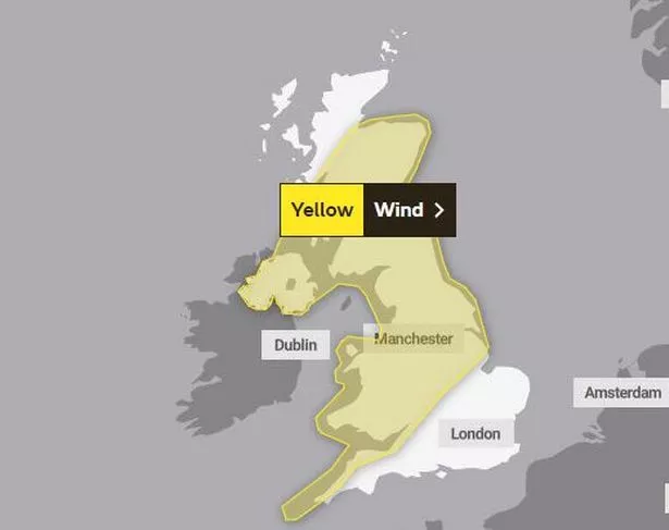
According to the Met Office, Storm Agnes is expected to approach southwest Ireland on Wednesday and then track northeast across Northern Ireland and Scotland before clearing the region on Thursday morning. While there remains some uncertainty about the storm’s exact trajectory and depth, gusty winds are anticipated across the UK.
The warning suggests that inland areas can expect gusts of 45-55 mph, with higher speeds of 50-60 mph over hills and coastal regions. The most severe winds are anticipated in Northern Ireland, southwest Scotland, western and northwest Wales, as well as parts of Cumbria and Lancashire. Here, gusts of up to 60 mph inland and 65-75 mph along the coasts are likely, primarily during the latter half of Wednesday afternoon and into the evening.
In addition to strong winds, the Met Office’s wind warning highlights the potential for building damage, power cuts, and significant transport disruption. Some roads and bridges may need to be closed for safety reasons.

Furthermore, the upgraded warning includes a caution about the possibility of injuries and danger to life caused by large waves and beach materials being thrown onto seafronts, coastal roads, and properties. Minor coastal road flooding is also a concern.
Storm Agnes is the first named storm of the current storm naming season, which runs from September to August the following year. While the storm’s influence on UK weather is expected to diminish on Thursday as it weakens and moves further north, southern areas could experience rain late on Thursday and into Friday, potentially with heavy bursts.
However, the Met Office offers a glimmer of hope as it anticipates a shift towards more settled weather over the weekend, thanks to a ridge of high pressure moving in from the south. Nevertheless, some northern and western areas may continue to experience showers for a time.
As the UK braces for the potential impacts of Storm Agnes, citizens are urged to stay informed through official weather updates and exercise caution during the storm’s passage.