

 CEREDIGION COUNTY COUNCIL has started its first review of the Rights of Way Improvement Plan.
Establishing such a plan was a requirement under the Countryside and Rights of Way Act 2000 – it is also required that the plan is reviewed every 10 years.
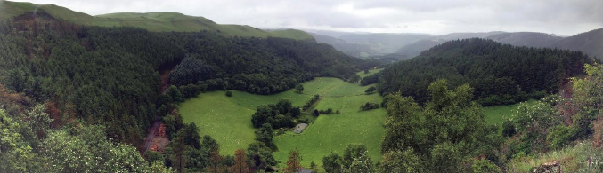
The network of public paths in Ceredigion – which total some 2,500km in length – provides one of the main means by which people can access and enjoy the countryside. Rights of way are an essential part of the rural tourism product in Ceredigion and they also have a key role to play in health and well-being. At the same time, the rights of way network is part of the local travel infrastructure, providing paths from people’s homes to local facilities and places of work.
ACCESS ALL AREAS
Ceredigion also has a large number of access and wildlife sites managed by a number of national, regional and local organisations.

Many woodlands managed by the NRW offer access opportunities for walkers, horse rides and cyclists; some sites have car parking and other facilities (such as way-marked trails) and guided walks. Information is also available for some woodlands. The most important recreational sites in Ceredigion are Nant yr Arian and Hafod.
The NRW has dedicated many of its woodlands for public access under the CROW Act 2000. In these areas, the public can enjoy the same statutory rights of access as on other ‘access land’.
There are seven National Nature Reserves wholly or partly in Ceredigion, managed by NRW and other conservation organisations. These sites provide an opportunity to enjoy their special wildlife interest. Improvements at Cors Caron NNR (Tregaron) carried out several years ago included the development of an all-ability trail across the reserve.
The council manages Local Nature Reserves in the Aberystwyth area, at Parc Natur Penglais, Pendinas and Traeth Tan y Bwlch and Coed y Cwm, together with other countryside sites that meet access and conservation objectives. There are a number of other sites that are available to the public, managed by organisations including the National Trust, the Wildlife Trust of South and West Wales, the Woodland Trust and others.
Access opportunities have been provided through Tir Gofal permissive access agreements; arrangements for identifying permissive access through the Glastir scheme are currently under consideration.

IMPROVEMENT PLAN’S PURPOSE
The Rights of Way Improvement Plan is the main plan used by local authorities to identify, prioritise and plan for improvements to their local rights of way network – and in doing so make better provision for walkers, cyclists, equestrians, carriage drivers, off road motorists and people with mobility problems. The Plan also takes account of the significant amount of access land that was made available in Wales under the Countryside and Rights of Way Act.
The review plans to set out a timeline for the completion of the review to the Ceredigion County Council Cabinet – which has been completed – and also to carry out the review addressing the statutory and supplementary matters.
Statutory matters include considering the extent to which the Rights of Way meet the present and future needs of the public; the opportunities provided by our rights of way for exercise and other forms of open air recreation and enjoyment; and also consider the accessibility of rights of way to blind or partially sighted people and others with mobility problems.
Supplementary matters also review the extent to which the previous Rights of Way Improvement Plan has been delivered, an evaluation of the present condition of the network and its record and review opportunities to contribute to Active Travel objectives, well-being objectives and delivery of other plans and priorities.

TOURISM IMPACT
The Rights of Way Improvement Plan is part of a raft of legislation, both primary and secondary, which sets out a series of aims which the council is supposed to meet when considering the provision of rights of way, their management, and their maintenance.
A key issue touching upon Ceredigion’s rights of way is the considerable boost they give to tourism across the county and the economic benefits that flow from visitors to Ceredigion, particularly for walking or cycling holidays.
The provision of the rights of way has not been untouched by controversy, with one landowner, Lyn Jenkins of Cardigan Island Coastal Farm Park, fighting a seemingly interminable and increasingly vituperative legal battle with the local authority to divert the Ceredigion Coast Path, now part of the Wales Coastal Path, away from his property.
In addition, farmers have expressed concern regarding biosecurity and disturbance to livestock by the extension of public access to private land.
Cllr Gareth Lloyd, the Cabinet Member with responsibility for Economic and Community Development Services, said: “Maintaining and reviewing the Rights of Way is important to ensure their enjoyment by the residents of Ceredigion. The Rights of Way Improvement Plan will give us the information needed to achieve this.”
Based on the information in the assessments, a decision will be made on whether to amend the Plan. The review will produce a draft plan and ancillary delivery plans and proceed through the consultation process to publication.
Following the review, a decision whether or not to publish a new Rights of Way Improvement Plan needs to be reached within 10 years of the date of publication of the original plan. This leaves the Authority until September 2018 to make that decision, which will be based on statutory assessments and stakeholder consultations.
WHAT IS A RIGHT OF WAY?
The categories of rights of way and their legal uses on public rights of way are as follows:
Public Footpaths:
A footpath is a highway over which the public have a right of way on foot. §
Bridleways:
A bridleway is a highway over which there is a right of way on foot, riding or leading a horse or cycling.
Restricted Byways:
A restricted byway allows a right of way on foot, on horseback, or leading a horse, cycling and for any vehicles other than mechanically propelled vehicles (formerly Roads Used as Public Paths).
Byways Open to all Traffic (BOAT):
A byway is a right of way which is open to all types of users, (including use by horse drawn and motor vehicles) but which is used mainly for the purposes for which footpaths and bridleways are used.
There are also 830km of Unclassified Road Network (UCRs) in Ceredigion, of which approximately 40km (4.8%) are unsurfaced: these are identified as ‘ORPAs’ on Ordnance Survey maps. These routes provide valuable recreational opportunities and whilst the council has a clear maintenance liability, public access rights may not be definitively known.


Add Comment