


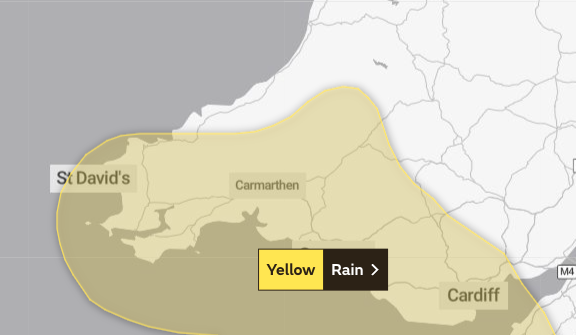
A Met Office weather warning is casting a shadow over Pembrokeshire and west Wales as up to 50mm of rain is predicted to drench the region. The yellow alert, effective from midnight on Friday to 10 am on Saturday, has heightened concerns, particularly in areas already grappling with the aftermath of weeks of above-average rainfall.
The forecasting agency emphasises that the rain, particularly in southwestern parts of the UK, is expected to be “heavy at times.” Weather maps vividly illustrate the impending deluge, with heavy rain anticipated throughout Friday night and into the early hours of Saturday morning.
In light of the grim forecast, Natural Resources Wales has issued flood alerts in the Lower Dee area and south Pembrokeshire, underscoring the potential risks posed by the relentless downpour. As south parts of the country brace for the impact of the weather system, residents are urged to exercise caution and stay updated on developments.
This unsettling weather phenomenon adds to what has already been one of the wettest autumns on record. The Met Office highlights that the jet stream’s shifting position next week may bring about a change in weather patterns, offering a glimmer of hope for those yearning for respite from the persistent rain.
“The associated weather system should clear to the east during Saturday afternoon, with more showery conditions following. 10 to 15mm is expected widely in the warning area, with a few places near southern coasts and over high ground seeing 20 to 30mm, with a chance that the southern slopes of Dartmoor and the hills of southwest Wales could see 40 to 50mm,” states the latest Met Office alert.

The areas covered by the warning span across Blaenau Gwent, Bridgend, Caerphilly, Cardiff, Carmarthenshire, Ceredigion, Merthyr Tydfil, Neath Port Talbot, Newport, Pembrokeshire, Powys, Rhondda Cynon Taf, Swansea, Torfaen, and Vale of Glamorgan.
As Friday unfolds, the Met Office forecast for Wales predicts a bright and mostly dry day, albeit with the possibility of the odd shower during the morning. However, the weather is expected to take a turn for the worse as the day progresses, with rain pushing through in the evening and overnight. The night is expected to be milder, with a minimum temperature of 7°C.
Saturday is set to bring a wet and windy start to the weekend, with outbreaks of rain gradually clearing northeastwards through the morning. Despite the lingering winds, some brighter spells are anticipated in the afternoon, providing a temporary respite from the deluge. The maximum temperature is expected to reach 15°C.
Looking ahead to Sunday to Tuesday, the forecast suggests a mix of blustery showers, longer spells of rain, and intermittent sunny spells. Conditions are expected to turn drier on Tuesday, accompanied by easing winds, with temperatures returning to average.
As Wales braces for the impending rainfall, residents are advised to stay informed, take necessary precautions, and monitor updates from local authorities. The tale of this meteorological drama continues to unfold, and the residents of Pembrokeshire and beyond remain vigilant in the face of nature’s unpredictable temperament.